


2022-09-10_10h58m21_Parcours découverte du Puy-en-Velay et de ses monuments

Gegetop
User
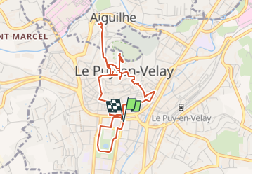

Length
5.1 km

Max alt
723 m

Uphill gradient
169 m
Km-Effort
7.3 km

Min alt
621 m

Downhill gradient
169 m
Boucle
Yes
Creation date :
2022-09-10 08:58:21.796
Updated on :
2022-09-12 15:07:23.027
1h39
Difficulty : Medium

FREE GPS app for hiking
 SityTrail
IGN / Geographical institutes
SityTrail Plus
The world is yours!
About
Trail Walking of 5.1 km to be discovered at Auvergne-Rhône-Alpes, Haute-Loire, Le Puy-en-Velay. This trail is proposed by Gegetop.
Photos

Positioning
Country:
France
Region :
Auvergne-Rhône-Alpes
Department/Province :
Haute-Loire
Municipality :
Le Puy-en-Velay
Location:
Unknown
Start:(Dec)
Start:(UTM)
569746 ; 4987956 (31T) N.
Comments