


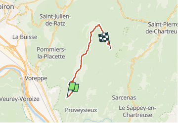
De Mont Saint Martin au col de la Charmette par le Col de la Sure - 04 sept 2022

morganee
User

Length
15.1 km

Max alt
1757 m

Uphill gradient
1148 m
Km-Effort
29 km

Min alt
802 m

Downhill gradient
673 m
Boucle
No
Creation date :
2022-09-04 05:04:34.597
Updated on :
2022-09-10 19:12:35.775
6h45
Difficulty : Medium

FREE GPS app for hiking
 SityTrail
IGN / Geographical institutes
SityTrail Plus
The world is yours!
About
Trail Walking of 15.1 km to be discovered at Auvergne-Rhône-Alpes, Isère, Mont-Saint-Martin. This trail is proposed by morganee.
Positioning
Country:
France
Region :
Auvergne-Rhône-Alpes
Department/Province :
Isère
Municipality :
Mont-Saint-Martin
Location:
Unknown
Start:(Dec)
Start:(UTM)
710132 ; 5016781 (31T) N.
Comments