


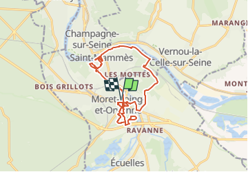
Moret et Saint Mammès

JLKino
User

Length
14.4 km

Max alt
105 m

Uphill gradient
148 m
Km-Effort
16.4 km

Min alt
39 m

Downhill gradient
148 m
Boucle
Yes
Creation date :
2022-09-11 08:28:05.06
Updated on :
2022-09-11 08:29:59.301
3h43
Difficulty : Easy

FREE GPS app for hiking
 SityTrail
IGN / Geographical institutes
SityTrail Plus
The world is yours!
About
Trail On foot of 14.4 km to be discovered at Ile-de-France, Seine-et-Marne, Moret-Loing-et-Orvanne. This trail is proposed by JLKino.
Positioning
Country:
France
Region :
Ile-de-France
Department/Province :
Seine-et-Marne
Municipality :
Moret-Loing-et-Orvanne
Location:
Moret-sur-Loing
Start:(Dec)
Start:(UTM)
486512 ; 5357941 (31U) N.
Comments