


col de l'Echarasson. Lrs yeux de Miroflée.

LydiaMich
User
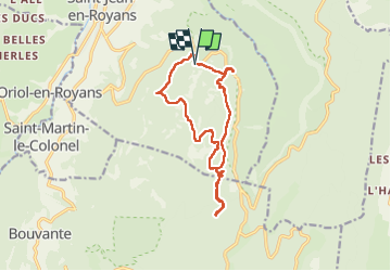

Length
13.6 km

Max alt
1167 m

Uphill gradient
518 m
Km-Effort
21 km

Min alt
824 m

Downhill gradient
515 m
Boucle
Yes
Creation date :
2022-09-11 07:16:43.078
Updated on :
2022-09-11 13:09:03.649
3h56
Difficulty : Easy

FREE GPS app for hiking
 SityTrail
IGN / Geographical institutes
SityTrail Plus
The world is yours!
About
Trail Walking of 13.6 km to be discovered at Auvergne-Rhône-Alpes, Drôme, Saint-Jean-en-Royans. This trail is proposed by LydiaMich .
Positioning
Country:
France
Region :
Auvergne-Rhône-Alpes
Department/Province :
Drôme
Municipality :
Saint-Jean-en-Royans
Location:
Unknown
Start:(Dec)
Start:(UTM)
682864 ; 4985918 (31T) N.
Comments