


Dulphey Mancey Col de Beaufer page 164

grasgilbert
User
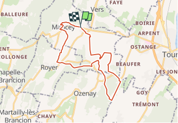

Length
13.7 km

Max alt
345 m

Uphill gradient
335 m
Km-Effort
18.2 km

Min alt
213 m

Downhill gradient
337 m
Boucle
Yes
Creation date :
2022-09-12 08:40:32.507
Updated on :
2024-10-10 17:11:31.839
4h07
Difficulty : Difficult

FREE GPS app for hiking
 SityTrail
IGN / Geographical institutes
SityTrail Plus
The world is yours!
About
Trail Walking of 13.7 km to be discovered at Bourgogne-Franche-Comté, Saône-et-Loire, Mancey. This trail is proposed by grasgilbert.
Description
essai rando Jean Claude
Positioning
Country:
France
Region :
Bourgogne-Franche-Comté
Department/Province :
Saône-et-Loire
Municipality :
Mancey
Location:
Unknown
Start:(Dec)
Start:(UTM)
641390 ; 5159540 (31T) N.
Comments
tres agréable. Bon niveau
bien