


le tour du garri de claude

Coryphene
User
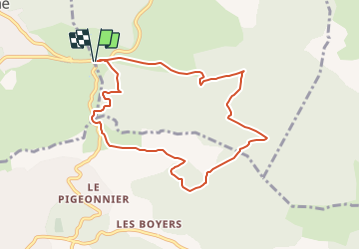

Length
9 km

Max alt
485 m

Uphill gradient
224 m
Km-Effort
12 km

Min alt
335 m

Downhill gradient
224 m
Boucle
Yes
Creation date :
2022-09-12 12:48:18.831
Updated on :
2023-11-25 08:54:07.411
2h43
Difficulty : Difficult

FREE GPS app for hiking
 SityTrail
IGN / Geographical institutes
SityTrail Plus
The world is yours!
About
Trail Walking of 9 km to be discovered at Provence-Alpes-Côte d'Azur, Bouches-du-Rhône, Peynier. This trail is proposed by Coryphene.
Positioning
Country:
France
Region :
Provence-Alpes-Côte d'Azur
Department/Province :
Bouches-du-Rhône
Municipality :
Peynier
Location:
Unknown
Start:(Dec)
Start:(UTM)
711303 ; 4810617 (31T) N.
Comments
super