


2022 09 LARCHANT. T1

michel1025
User
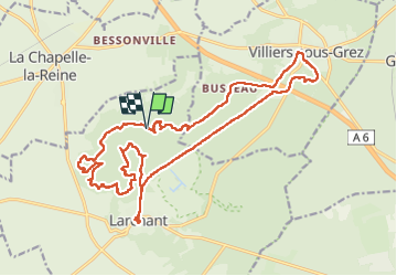

Length
23 km

Max alt
124 m

Uphill gradient
346 m
Km-Effort
27 km

Min alt
64 m

Downhill gradient
346 m
Boucle
Yes
Creation date :
2022-09-12 08:14:50.0
Updated on :
2022-09-12 14:40:13.183
6h11
Difficulty : Very difficult

FREE GPS app for hiking
 SityTrail
IGN / Geographical institutes
SityTrail Plus
The world is yours!
About
Trail Walking of 23 km to be discovered at Ile-de-France, Seine-et-Marne, Larchant. This trail is proposed by michel1025.
Positioning
Country:
France
Region :
Ile-de-France
Department/Province :
Seine-et-Marne
Municipality :
Larchant
Location:
Unknown
Start:(Dec)
Start:(UTM)
470251 ; 5350101 (31U) N.
Comments