


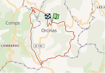
Oricanas - Col de Vesc

psmets
User

Length
9.8 km

Max alt
808 m

Uphill gradient
410 m
Km-Effort
15.2 km

Min alt
500 m

Downhill gradient
401 m
Boucle
Yes
Creation date :
2022-09-12 17:38:59.989
Updated on :
2022-09-12 17:40:00.564
3h27
Difficulty : Difficult

FREE GPS app for hiking
 SityTrail
IGN / Geographical institutes
SityTrail Plus
The world is yours!
About
Trail Walking of 9.8 km to be discovered at Auvergne-Rhône-Alpes, Drôme, Orcinas. This trail is proposed by psmets.
Positioning
Country:
France
Region :
Auvergne-Rhône-Alpes
Department/Province :
Drôme
Municipality :
Orcinas
Location:
Unknown
Start:(Dec)
Start:(UTM)
669590 ; 4935460 (31T) N.
Comments