


M’utilisa

raygautier
User
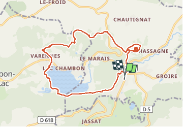

Length
10.8 km

Max alt
1069 m

Uphill gradient
384 m
Km-Effort
16 km

Min alt
832 m

Downhill gradient
389 m
Boucle
Yes
Creation date :
2022-09-12 09:22:32.0
Updated on :
2022-09-13 06:21:53.345
3h01
Difficulty : Difficult

FREE GPS app for hiking
 SityTrail
IGN / Geographical institutes
SityTrail Plus
The world is yours!
About
Trail Walking of 10.8 km to be discovered at Auvergne-Rhône-Alpes, Puy-de-Dôme, Murol. This trail is proposed by raygautier.
Positioning
Country:
France
Region :
Auvergne-Rhône-Alpes
Department/Province :
Puy-de-Dôme
Municipality :
Murol
Location:
Unknown
Start:(Dec)
Start:(UTM)
495433 ; 5046397 (31T) N.
Comments