


le violon la Canourgue

Dupuybadonniere
User
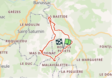

Length
13 km

Max alt
950 m

Uphill gradient
338 m
Km-Effort
17.5 km

Min alt
770 m

Downhill gradient
337 m
Boucle
Yes
Creation date :
2022-07-07 07:47:35.523
Updated on :
2022-09-15 12:02:05.33
3h29
Difficulty : Difficult

FREE GPS app for hiking
 SityTrail
IGN / Geographical institutes
SityTrail Plus
The world is yours!
About
Trail Walking of 13 km to be discovered at Occitania, Lozère, La Canourgue. This trail is proposed by Dupuybadonniere.
Positioning
Country:
France
Region :
Occitania
Department/Province :
Lozère
Municipality :
La Canourgue
Location:
La Canourgue
Start:(Dec)
Start:(UTM)
517932 ; 4916117 (31T) N.
Comments