


rando du parc

Tommy Eric
User
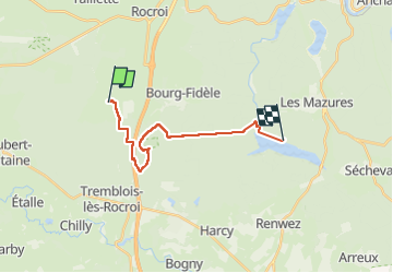

Length
14.5 km

Max alt
385 m

Uphill gradient
165 m
Km-Effort
17.1 km

Min alt
238 m

Downhill gradient
276 m
Boucle
No
Creation date :
2022-09-15 11:34:50.748
Updated on :
2022-09-15 15:34:21.524
3h25
Difficulty : Difficult

FREE GPS app for hiking
 SityTrail
IGN / Geographical institutes
SityTrail Plus
The world is yours!
About
Trail Walking of 14.5 km to be discovered at Grand Est, Ardennes, Sévigny-la-Forêt. This trail is proposed by Tommy Eric.
Positioning
Country:
France
Region :
Grand Est
Department/Province :
Ardennes
Municipality :
Sévigny-la-Forêt
Location:
Unknown
Start:(Dec)
Start:(UTM)
607356 ; 5527238 (31U) N.
Comments