


Orcivall

raygautier
User
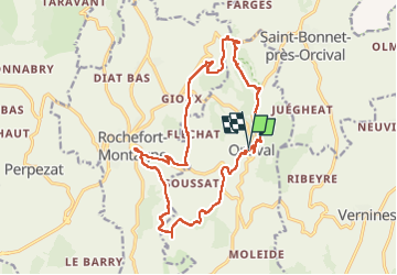

Length
19.2 km

Max alt
1085 m

Uphill gradient
548 m
Km-Effort
26 km

Min alt
782 m

Downhill gradient
552 m
Boucle
Yes
Creation date :
2022-09-16 07:42:48.0
Updated on :
2022-09-17 18:10:17.637
4h40
Difficulty : Very difficult

FREE GPS app for hiking
 SityTrail
IGN / Geographical institutes
SityTrail Plus
The world is yours!
About
Trail Walking of 19.2 km to be discovered at Auvergne-Rhône-Alpes, Puy-de-Dôme, Orcival. This trail is proposed by raygautier.
Positioning
Country:
France
Region :
Auvergne-Rhône-Alpes
Department/Province :
Puy-de-Dôme
Municipality :
Orcival
Location:
Unknown
Start:(Dec)
Start:(UTM)
487653 ; 5058832 (31T) N.
Comments