


Descente du ventoux Vtt par Bédouin

denel
User
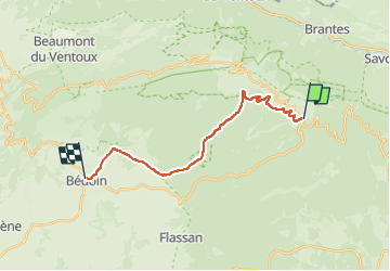

Length
17.7 km

Max alt
1534 m

Uphill gradient
168 m
Km-Effort
24 km

Min alt
311 m

Downhill gradient
1283 m
Boucle
No
Creation date :
2022-09-18 08:09:06.183
Updated on :
2022-09-18 09:54:15.96
1h44
Difficulty : Medium

FREE GPS app for hiking
 SityTrail
IGN / Geographical institutes
SityTrail Plus
The world is yours!
About
Trail Mountain bike of 17.7 km to be discovered at Provence-Alpes-Côte d'Azur, Vaucluse, Bédoin. This trail is proposed by denel.
Positioning
Country:
France
Region :
Provence-Alpes-Côte d'Azur
Department/Province :
Vaucluse
Municipality :
Bédoin
Location:
Unknown
Start:(Dec)
Start:(UTM)
685440 ; 4891400 (31T) N.
Comments