


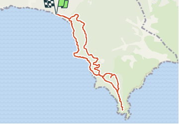
la croix de valmer jusqu'au cap lardier

pln30
User

Length
9.4 km

Max alt
142 m

Uphill gradient
263 m
Km-Effort
12.9 km

Min alt
4 m

Downhill gradient
264 m
Boucle
Yes
Creation date :
2022-09-18 06:25:37.183
Updated on :
2022-09-24 06:47:39.163
3h18
Difficulty : Medium

FREE GPS app for hiking
 SityTrail
IGN / Geographical institutes
SityTrail Plus
The world is yours!
About
Trail Walking of 9.4 km to be discovered at Provence-Alpes-Côte d'Azur, Var, La Croix-Valmer. This trail is proposed by pln30.
Description
une randonnée qui aurait pu être belle si le cap lardier avait été débarrassé du bois mort après les incendies de 2017
la vidéo de la randonnée sur ma chaine youtube Air View Channel
Photos

Positioning
Country:
France
Region :
Provence-Alpes-Côte d'Azur
Department/Province :
Var
Municipality :
La Croix-Valmer
Location:
Unknown
Start:(Dec)
Start:(UTM)
304715 ; 4784135 (32T) N.
Comments