


belle done

manumax
User
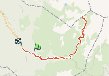

Length
12.8 km

Max alt
2376 m

Uphill gradient
1001 m
Km-Effort
26 km

Min alt
1313 m

Downhill gradient
1070 m
Boucle
No
Creation date :
2022-09-18 08:01:54.418
Updated on :
2022-09-18 14:47:55.099
6h45
Difficulty : Very difficult

FREE GPS app for hiking
 SityTrail
IGN / Geographical institutes
SityTrail Plus
The world is yours!
About
Trail Walking of 12.8 km to be discovered at Auvergne-Rhône-Alpes, Isère, Laval-en-Belledonne. This trail is proposed by manumax.
Positioning
Country:
France
Region :
Auvergne-Rhône-Alpes
Department/Province :
Isère
Municipality :
Laval-en-Belledonne
Location:
Unknown
Start:(Dec)
Start:(UTM)
264524 ; 5012245 (32T) N.
Comments