


2022-09-11-02

Laurent53
User
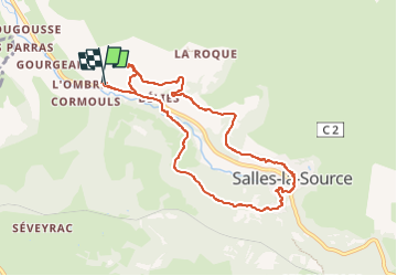

Length
8.8 km

Max alt
448 m

Uphill gradient
242 m
Km-Effort
12.1 km

Min alt
314 m

Downhill gradient
243 m
Boucle
Yes
Creation date :
2022-09-18 15:03:18.623
Updated on :
2022-09-18 16:46:26.568
2h44
Difficulty : Easy

FREE GPS app for hiking
 SityTrail
IGN / Geographical institutes
SityTrail Plus
The world is yours!
About
Trail On foot of 8.8 km to be discovered at Occitania, Aveyron, Salles-la-Source. This trail is proposed by Laurent53.
Positioning
Country:
France
Region :
Occitania
Department/Province :
Aveyron
Municipality :
Salles-la-Source
Location:
Unknown
Start:(Dec)
Start:(UTM)
459005 ; 4921675 (31T) N.
Comments