


Pernes les Fontaines

PhilippeC54
User
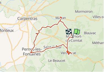

Length
35 km

Max alt
297 m

Uphill gradient
440 m
Km-Effort
41 km

Min alt
82 m

Downhill gradient
445 m
Boucle
Yes
Creation date :
2022-09-19 12:53:19.629
Updated on :
2022-09-19 15:56:15.855
2h26
Difficulty : Medium

FREE GPS app for hiking
 SityTrail
IGN / Geographical institutes
SityTrail Plus
The world is yours!
About
Trail Road bike of 35 km to be discovered at Provence-Alpes-Côte d'Azur, Vaucluse, Malemort-du-Comtat. This trail is proposed by PhilippeC54.
Positioning
Country:
France
Region :
Provence-Alpes-Côte d'Azur
Department/Province :
Vaucluse
Municipality :
Malemort-du-Comtat
Location:
Unknown
Start:(Dec)
Start:(UTM)
672891 ; 4876554 (31T) N.
Comments