


argences01

marco14
User
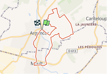

Length
8.8 km

Max alt
71 m

Uphill gradient
98 m
Km-Effort
10.1 km

Min alt
12 m

Downhill gradient
97 m
Boucle
Yes
Creation date :
2022-09-20 09:15:39.095
Updated on :
2022-09-20 23:18:37.853
2h17
Difficulty : Medium

FREE GPS app for hiking
 SityTrail
IGN / Geographical institutes
SityTrail Plus
The world is yours!
About
Trail Walking of 8.8 km to be discovered at Normandy, Calvados, Argences. This trail is proposed by marco14.
Positioning
Country:
France
Region :
Normandy
Department/Province :
Calvados
Municipality :
Argences
Location:
Unknown
Start:(Dec)
Start:(UTM)
707004 ; 5445611 (30U) N.
Comments