


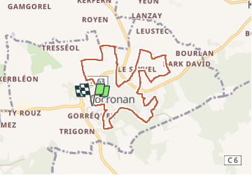
La randonnée de Locronan par mes chemins creux

alainjoseph6
User

Length
9.3 km

Max alt
219 m

Uphill gradient
207 m
Km-Effort
12.1 km

Min alt
77 m

Downhill gradient
207 m
Boucle
Yes
Creation date :
2022-09-20 07:11:24.098
Updated on :
2022-10-23 06:31:53.664
3h30
Difficulty : Medium

FREE GPS app for hiking
 SityTrail
IGN / Geographical institutes
SityTrail Plus
The world is yours!
About
Trail Walking of 9.3 km to be discovered at Brittany, Finistère, Locronan. This trail is proposed by alainjoseph6.
Description
Superbe balade autour de Locronan par les chemins creux.
Photos


Positioning
Country:
France
Region :
Brittany
Department/Province :
Finistère
Municipality :
Locronan
Location:
Unknown
Start:(Dec)
Start:(UTM)
409733 ; 5327838 (30U) N.
Comments