


ventoux

losjo
User
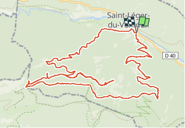

Length
19 km

Max alt
1021 m

Uphill gradient
949 m
Km-Effort
32 km

Min alt
398 m

Downhill gradient
947 m
Boucle
Yes
Creation date :
2022-09-20 07:18:38.579
Updated on :
2022-09-20 15:59:25.352
8h40
Difficulty : Very difficult

FREE GPS app for hiking
 SityTrail
IGN / Geographical institutes
SityTrail Plus
The world is yours!
About
Trail Walking of 19 km to be discovered at Provence-Alpes-Côte d'Azur, Vaucluse, Saint-Léger-du-Ventoux. This trail is proposed by losjo.
Description
rando
Positioning
Country:
France
Region :
Provence-Alpes-Côte d'Azur
Department/Province :
Vaucluse
Municipality :
Saint-Léger-du-Ventoux
Location:
Unknown
Start:(Dec)
Start:(UTM)
682040 ; 4897594 (31T) N.
Comments