


flamanville

canal
User
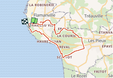

Length
14.9 km

Max alt
128 m

Uphill gradient
263 m
Km-Effort
18.4 km

Min alt
3 m

Downhill gradient
260 m
Boucle
Yes
Creation date :
2022-09-21 08:21:37.689
Updated on :
2022-09-21 14:30:36.615
6h08
Difficulty : Difficult

FREE GPS app for hiking
 SityTrail
IGN / Geographical institutes
SityTrail Plus
The world is yours!
About
Trail Walking of 14.9 km to be discovered at Normandy, Manche, Flamanville. This trail is proposed by canal.
Description
bocage
Positioning
Country:
France
Region :
Normandy
Department/Province :
Manche
Municipality :
Flamanville
Location:
Unknown
Start:(Dec)
Start:(UTM)
580914 ; 5486178 (30U) N.
Comments