


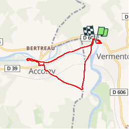
BMF-140824 - Vincelles-Vermenton-Accolay

randodan
User


1h40
Difficulty : Unknown

FREE GPS app for hiking
 SityTrail
IGN / Geographical institutes
SityTrail Plus
The world is yours!
About
Trail Walking of 6.2 km to be discovered at Bourgogne-Franche-Comté, Yonne, Vermenton. This trail is proposed by randodan.
Description
Vincelles - Vermenton - Accolay<br>
- Dimanche 24 août 2014 -<br>
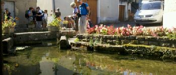
10h40, départ de Vermenton . Longeons le Canal d'Accolay (chouette... des noyers !), visite des lavoirs . Retour par la Croix de Montacout.<br>
12h20, allons nous installer pour pique-niquer sur notre île habituelle au Parc Municipal des Îles.<br>
L'après-midi - après une courte sieste pour certains - sera consacrée à un grand tournoi de pétanque.<br>
22 participants.
Photos


Positioning
Comments