


le marais de Fenain

BrassensJC
User

Length
7.6 km

Max alt
28 m

Uphill gradient
27 m
Km-Effort
7.9 km

Min alt
13 m

Downhill gradient
27 m
Boucle
Yes
Creation date :
2022-09-21 15:08:07.528
Updated on :
2022-09-21 15:08:47.672
1h48
Difficulty : Medium

FREE GPS app for hiking
 SityTrail
IGN / Geographical institutes
SityTrail Plus
The world is yours!
About
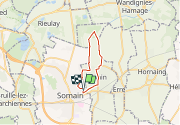
Trail Walking of 7.6 km to be discovered at Hauts-de-France, Nord, Somain. This trail is proposed by BrassensJC.
Positioning
Country:
France
Region :
Hauts-de-France
Department/Province :
Nord
Municipality :
Somain
Location:
Unknown
Start:(Dec)
Start:(UTM)
520647 ; 5578828 (31U) N.
Comments