


broceliande_barenton

cmar
User
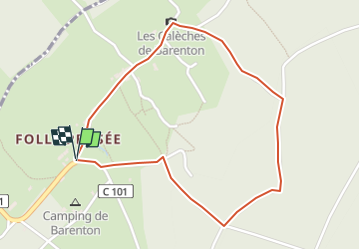

Length
2.1 km

Max alt
183 m

Uphill gradient
46 m
Km-Effort
2.7 km

Min alt
130 m

Downhill gradient
49 m
Boucle
Yes
Creation date :
2022-09-21 19:36:59.525
Updated on :
2022-09-21 19:37:51.718
36m
Difficulty : Easy

FREE GPS app for hiking
 SityTrail
IGN / Geographical institutes
SityTrail Plus
The world is yours!
About
Trail Walking of 2.1 km to be discovered at Brittany, Ille-et-Vilaine, Paimpont. This trail is proposed by cmar.
Positioning
Country:
France
Region :
Brittany
Department/Province :
Ille-et-Vilaine
Municipality :
Paimpont
Location:
Unknown
Start:(Dec)
Start:(UTM)
555069 ; 5320726 (30U) N.
Comments