


freydieres-refuge de la pra

maupassant38
User
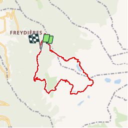

Length
15.8 km

Max alt
2381 m

Uphill gradient
1214 m
Km-Effort
32 km

Min alt
1308 m

Downhill gradient
1215 m
Boucle
Yes
Creation date :
2019-02-22 22:32:00.946
Updated on :
2019-02-22 22:32:00.969
4h40
Difficulty : Medium

FREE GPS app for hiking
 SityTrail
IGN / Geographical institutes
SityTrail Plus
The world is yours!
About
Trail Walking of 15.8 km to be discovered at Auvergne-Rhône-Alpes, Isère, Revel. This trail is proposed by maupassant38.
Positioning
Country:
France
Region :
Auvergne-Rhône-Alpes
Department/Province :
Isère
Municipality :
Revel
Location:
Unknown
Start:(Dec)
Start:(UTM)
728622 ; 5006906 (31T) N.
Comments