


Tutorat château Villeroy

jeanmarcMasson
User GUIDE
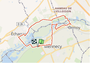

Length
8.7 km

Max alt
70 m

Uphill gradient
90 m
Km-Effort
9.9 km

Min alt
43 m

Downhill gradient
90 m
Boucle
Yes
Creation date :
2022-09-22 12:06:54.816
Updated on :
2022-09-22 14:32:45.16
2h09
Difficulty : Medium

FREE GPS app for hiking
 SityTrail
IGN / Geographical institutes
SityTrail Plus
The world is yours!
About
Trail Walking of 8.7 km to be discovered at Ile-de-France, Essonne, Mennecy. This trail is proposed by jeanmarcMasson.
Positioning
Country:
France
Region :
Ile-de-France
Department/Province :
Essonne
Municipality :
Mennecy
Location:
Unknown
Start:(Dec)
Start:(UTM)
457526 ; 5379400 (31U) N.
Comments