


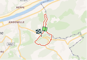
Andennelle (fond de Gorgin)

thomarche
User

Length
4.6 km

Max alt
225 m

Uphill gradient
132 m
Km-Effort
6.3 km

Min alt
90 m

Downhill gradient
137 m
Boucle
Yes
Creation date :
2022-09-23 07:54:15.0
Updated on :
2022-09-23 08:59:07.36
1h03
Difficulty : Easy

FREE GPS app for hiking
 SityTrail
IGN / Geographical institutes
SityTrail Plus
The world is yours!
About
Trail Walking of 4.6 km to be discovered at Wallonia, Namur, Andenne. This trail is proposed by thomarche.
Description
Magnifiquissime fond de vallée sauvage avec rivière (sentier refermé ronces par endroits mais ça passe)
Partie d’une rando de 13km par clthi: à explorer absolument (et variantes à faire déjà sur cette bouclette)
Positioning
Country:
Belgium
Region :
Wallonia
Department/Province :
Namur
Municipality :
Andenne
Location:
Unknown
Start:(Dec)
Start:(UTM)
651072 ; 5595130 (31U) N.
Comments