


de Nézel à Villennes sur Seine

jpcccb
User
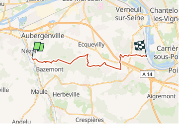

Length
16.8 km

Max alt
187 m

Uphill gradient
326 m
Km-Effort
21 km

Min alt
25 m

Downhill gradient
332 m
Boucle
No
Creation date :
2022-09-24 13:40:29.661
Updated on :
2023-05-07 12:01:48.715
4h49
Difficulty : Very difficult

FREE GPS app for hiking
 SityTrail
IGN / Geographical institutes
SityTrail Plus
The world is yours!
About
Trail Walking of 16.8 km to be discovered at Ile-de-France, Yvelines, Nézel. This trail is proposed by jpcccb.
Description
GR26 forêt des Alluets
Positioning
Country:
France
Region :
Ile-de-France
Department/Province :
Yvelines
Municipality :
Nézel
Location:
Unknown
Start:(Dec)
Start:(UTM)
415114 ; 5421306 (31U) N.
Comments