


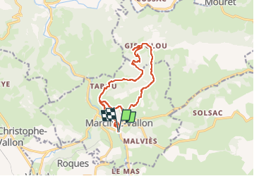
Marcillac St Jean le Froid

Laurent53
User

Length
14.8 km

Max alt
553 m

Uphill gradient
375 m
Km-Effort
19.8 km

Min alt
276 m

Downhill gradient
376 m
Boucle
Yes
Creation date :
2022-09-26 15:13:43.181
Updated on :
2022-09-26 15:17:08.672
4h30
Difficulty : Medium

FREE GPS app for hiking
 SityTrail
IGN / Geographical institutes
SityTrail Plus
The world is yours!
About
Trail On foot of 14.8 km to be discovered at Occitania, Aveyron, Marcillac-Vallon. This trail is proposed by Laurent53.
Positioning
Country:
France
Region :
Occitania
Department/Province :
Aveyron
Municipality :
Marcillac-Vallon
Location:
Unknown
Start:(Dec)
Start:(UTM)
457453 ; 4924371 (31T) N.
Comments