


Colombier

raygautier
User
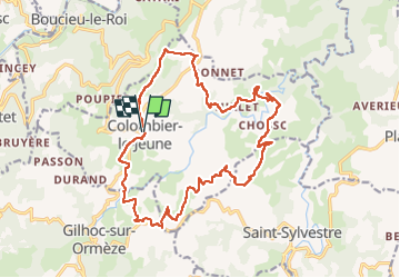

Length
20 km

Max alt
602 m

Uphill gradient
634 m
Km-Effort
29 km

Min alt
344 m

Downhill gradient
635 m
Boucle
Yes
Creation date :
2022-09-25 07:04:47.0
Updated on :
2022-09-26 15:26:22.816
4h51
Difficulty : Very difficult

FREE GPS app for hiking
 SityTrail
IGN / Geographical institutes
SityTrail Plus
The world is yours!
About
Trail Walking of 20 km to be discovered at Auvergne-Rhône-Alpes, Ardèche, Colombier-le-Jeune. This trail is proposed by raygautier.
Positioning
Country:
France
Region :
Auvergne-Rhône-Alpes
Department/Province :
Ardèche
Municipality :
Colombier-le-Jeune
Location:
Unknown
Start:(Dec)
Start:(UTM)
634119 ; 4985593 (31T) N.
Comments