


rando parc

Tommy Eric
User
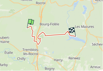

Length
15.2 km

Max alt
386 m

Uphill gradient
179 m
Km-Effort
17.9 km

Min alt
238 m

Downhill gradient
279 m
Boucle
No
Creation date :
2022-09-26 18:18:08.507
Updated on :
2022-09-26 18:18:10.268
4h04
Difficulty : Difficult

FREE GPS app for hiking
 SityTrail
IGN / Geographical institutes
SityTrail Plus
The world is yours!
About
Trail Walking of 15.2 km to be discovered at Grand Est, Ardennes, Sévigny-la-Forêt. This trail is proposed by Tommy Eric.
Positioning
Country:
France
Region :
Grand Est
Department/Province :
Ardennes
Municipality :
Sévigny-la-Forêt
Location:
Unknown
Start:(Dec)
Start:(UTM)
606919 ; 5526908 (31U) N.
Comments