


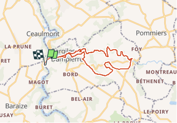
SityTrail - La Chaumerette,Gargilesse

jeanmarcMasson
User GUIDE

Length
15.8 km

Max alt
240 m

Uphill gradient
290 m
Km-Effort
19.7 km

Min alt
127 m

Downhill gradient
290 m
Boucle
Yes
Creation date :
2022-09-27 17:05:25.82
Updated on :
2022-09-27 17:09:00.488
4h28
Difficulty : Very difficult

FREE GPS app for hiking
 SityTrail
IGN / Geographical institutes
SityTrail Plus
The world is yours!
About
Trail Walking of 15.8 km to be discovered at Centre-Loire Valley, Indre, Gargilesse-Dampierre. This trail is proposed by jeanmarcMasson.
Positioning
Country:
France
Region :
Centre-Loire Valley
Department/Province :
Indre
Municipality :
Gargilesse-Dampierre
Location:
Unknown
Start:(Dec)
Start:(UTM)
391203 ; 5151472 (31T) N.
Comments