


SityTrail - aigurande ,la Vau vre

jeanmarcMasson
User GUIDE
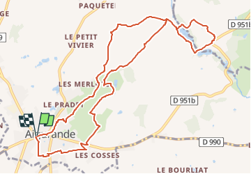

Length
12.3 km

Max alt
441 m

Uphill gradient
236 m
Km-Effort
15.4 km

Min alt
322 m

Downhill gradient
237 m
Boucle
Yes
Creation date :
2022-09-28 07:18:27.616
Updated on :
2022-09-28 07:26:03.301
3h30
Difficulty : Difficult

FREE GPS app for hiking
 SityTrail
IGN / Geographical institutes
SityTrail Plus
The world is yours!
About
Trail Walking of 12.3 km to be discovered at Centre-Loire Valley, Indre, Aigurande. This trail is proposed by jeanmarcMasson.
Positioning
Country:
France
Region :
Centre-Loire Valley
Department/Province :
Indre
Municipality :
Aigurande
Location:
Unknown
Start:(Dec)
Start:(UTM)
409847 ; 5142942 (31T) N.
Comments