


tracedetrail_161877

sterdyniak
User
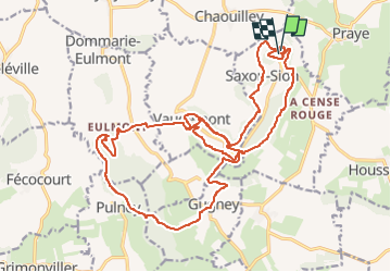

Length
25 km

Max alt
531 m

Uphill gradient
806 m
Km-Effort
36 km

Min alt
325 m

Downhill gradient
809 m
Boucle
Yes
Creation date :
2022-09-29 08:35:45.593
Updated on :
2022-09-29 08:35:59.34

FREE GPS app for hiking
 SityTrail
IGN / Geographical institutes
SityTrail Plus
The world is yours!
About
Trail of 25 km to be discovered at Grand Est, Meurthe-et-Moselle, Saxon-Sion. This trail is proposed by sterdyniak.
Positioning
Country:
France
Region :
Grand Est
Department/Province :
Meurthe-et-Moselle
Municipality :
Saxon-Sion
Location:
Unknown
Start:(Dec)
Start:(UTM)
284360 ; 5368355 (32U) N.
Comments