


Rocher de Carabasse

giovannoni
User
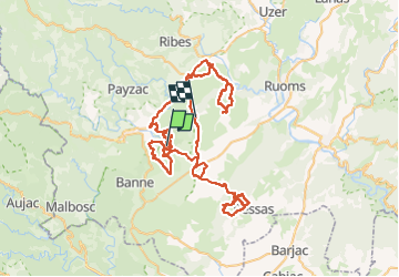

Length
141 km

Max alt
417 m

Uphill gradient
2579 m
Km-Effort
176 km

Min alt
107 m

Downhill gradient
2570 m
Boucle
No
Creation date :
2022-09-26 08:29:55.0
Updated on :
2022-09-29 15:24:51.586
77h16
Difficulty : Very easy

FREE GPS app for hiking
 SityTrail
IGN / Geographical institutes
SityTrail Plus
The world is yours!
About
Trail Walking of 141 km to be discovered at Auvergne-Rhône-Alpes, Ardèche, Berrias-et-Casteljau. This trail is proposed by giovannoni.
Positioning
Country:
France
Region :
Auvergne-Rhône-Alpes
Department/Province :
Ardèche
Municipality :
Berrias-et-Casteljau
Location:
Casteljau
Start:(Dec)
Start:(UTM)
595171 ; 4917127 (31T) N.
Comments