


Bj-E3

pascal.dabet
User
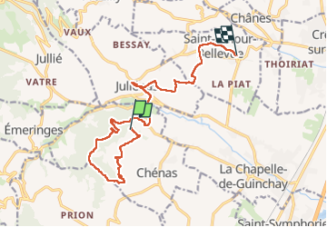

Length
14.9 km

Max alt
509 m

Uphill gradient
371 m
Km-Effort
20 km

Min alt
228 m

Downhill gradient
517 m
Boucle
No
Creation date :
2022-08-03 06:27:34.327
Updated on :
2022-10-01 14:40:48.559
7h02
Difficulty : Very difficult

FREE GPS app for hiking
 SityTrail
IGN / Geographical institutes
SityTrail Plus
The world is yours!
About
Trail Walking of 14.9 km to be discovered at Auvergne-Rhône-Alpes, Rhône, Chénas. This trail is proposed by pascal.dabet.
Positioning
Country:
France
Region :
Auvergne-Rhône-Alpes
Department/Province :
Rhône
Municipality :
Chénas
Location:
Unknown
Start:(Dec)
Start:(UTM)
631815 ; 5120291 (31T) N.
Comments