


BJ-E6 bis

pascal.dabet
User

Length
15.3 km

Max alt
702 m

Uphill gradient
447 m
Km-Effort
22 km

Min alt
302 m

Downhill gradient
522 m
Boucle
No
Creation date :
2022-08-06 06:25:59.401
Updated on :
2022-10-01 14:41:08.596
5h57
Difficulty : Very difficult

FREE GPS app for hiking
 SityTrail
IGN / Geographical institutes
SityTrail Plus
The world is yours!
About
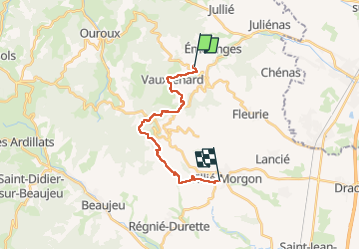
Trail Walking of 15.3 km to be discovered at Auvergne-Rhône-Alpes, Rhône, Vauxrenard. This trail is proposed by pascal.dabet.
Positioning
Country:
France
Region :
Auvergne-Rhône-Alpes
Department/Province :
Rhône
Municipality :
Vauxrenard
Location:
Unknown
Start:(Dec)
Start:(UTM)
627994 ; 5119245 (31T) N.
Comments