


Cheval Blanc

Patricelecerf
User
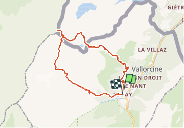

Length
20 km

Max alt
2817 m

Uphill gradient
1736 m
Km-Effort
43 km

Min alt
1350 m

Downhill gradient
1762 m
Boucle
No
Creation date :
2016-08-12 00:00:00.0
Updated on :
2016-08-12 00:00:00.0
12h04
Difficulty : Difficult

FREE GPS app for hiking
 SityTrail
IGN / Geographical institutes
SityTrail Plus
The world is yours!
About
Trail Walking of 20 km to be discovered at Auvergne-Rhône-Alpes, Upper Savoy, Vallorcine. This trail is proposed by Patricelecerf.
Description
30/31.08.14
Positioning
Country:
France
Region :
Auvergne-Rhône-Alpes
Department/Province :
Upper Savoy
Municipality :
Vallorcine
Location:
Unknown
Start:(Dec)
Start:(UTM)
338779 ; 5098849 (32T) N.
Comments