


1 er rando

jeanmarcMasson
User GUIDE

Length
16.9 km

Max alt
241 m

Uphill gradient
262 m
Km-Effort
20 km

Min alt
127 m

Downhill gradient
260 m
Boucle
Yes
Creation date :
2022-10-02 08:11:45.089
Updated on :
2022-10-02 13:55:55.483
3h58
Difficulty : Very difficult

FREE GPS app for hiking
 SityTrail
IGN / Geographical institutes
SityTrail Plus
The world is yours!
About
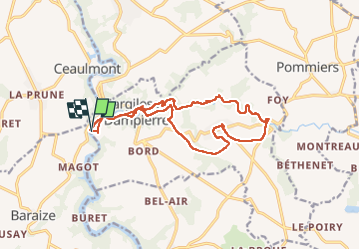
Trail Walking of 16.9 km to be discovered at Centre-Loire Valley, Indre, Gargilesse-Dampierre. This trail is proposed by jeanmarcMasson.
Positioning
Country:
France
Region :
Centre-Loire Valley
Department/Province :
Indre
Municipality :
Gargilesse-Dampierre
Location:
Unknown
Start:(Dec)
Start:(UTM)
391170 ; 5151531 (31T) N.
Comments