


Dionay

crocau
User
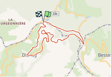

Length
9.6 km

Max alt
642 m

Uphill gradient
192 m
Km-Effort
12.1 km

Min alt
479 m

Downhill gradient
192 m
Boucle
Yes
Creation date :
2022-10-02 13:47:54.957
Updated on :
2022-10-02 15:42:16.282
1h54
Difficulty : Difficult

FREE GPS app for hiking
 SityTrail
IGN / Geographical institutes
SityTrail Plus
The world is yours!
About
Trail Walking of 9.6 km to be discovered at Auvergne-Rhône-Alpes, Isère, Roybon. This trail is proposed by crocau.
Photos


28 photos in total. Please click on a photo to see them all in the gallery.
Positioning
Country:
France
Region :
Auvergne-Rhône-Alpes
Department/Province :
Isère
Municipality :
Roybon
Location:
Unknown
Start:(Dec)
Start:(UTM)
674961 ; 5009434 (31T) N.
Comments