


NOAILHAC

CANON2
User
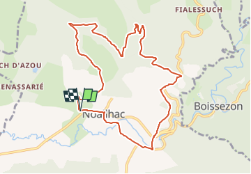

Length
10.8 km

Max alt
370 m

Uphill gradient
312 m
Km-Effort
15 km

Min alt
229 m

Downhill gradient
313 m
Boucle
Yes
Creation date :
2022-10-06 06:52:47.503
Updated on :
2022-10-06 06:53:28.168
3h24
Difficulty : Medium

FREE GPS app for hiking
 SityTrail
IGN / Geographical institutes
SityTrail Plus
The world is yours!
About
Trail Walking of 10.8 km to be discovered at Occitania, Tarn, Noailhac. This trail is proposed by CANON2.
Positioning
Country:
France
Region :
Occitania
Department/Province :
Tarn
Municipality :
Noailhac
Location:
Unknown
Start:(Dec)
Start:(UTM)
447131 ; 4824853 (31T) N.
Comments