


passerelle

Nila81
User
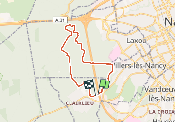

Length
12.8 km

Max alt
370 m

Uphill gradient
225 m
Km-Effort
15.8 km

Min alt
271 m

Downhill gradient
227 m
Boucle
Yes
Creation date :
2022-10-06 11:49:07.9
Updated on :
2022-10-06 14:41:30.456
2h51
Difficulty : Difficult

FREE GPS app for hiking
 SityTrail
IGN / Geographical institutes
SityTrail Plus
The world is yours!
About
Trail Walking of 12.8 km to be discovered at Grand Est, Meurthe-et-Moselle, Villers-lès-Nancy. This trail is proposed by Nila81.
Description
départ Clailieu
Positioning
Country:
France
Region :
Grand Est
Department/Province :
Meurthe-et-Moselle
Municipality :
Villers-lès-Nancy
Location:
Unknown
Start:(Dec)
Start:(UTM)
288293 ; 5393570 (32U) N.
Comments