


Clairlieu_13km

ZAMBAUX
User
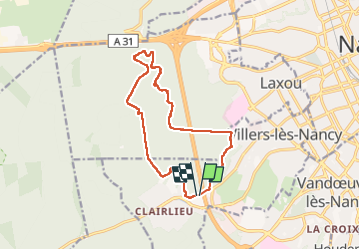

Length
13.3 km

Max alt
370 m

Uphill gradient
223 m
Km-Effort
16.3 km

Min alt
270 m

Downhill gradient
224 m
Boucle
Yes
Creation date :
2022-10-06 11:55:23.875
Updated on :
2022-10-07 16:35:19.212
2h28
Difficulty : Difficult

FREE GPS app for hiking
 SityTrail
IGN / Geographical institutes
SityTrail Plus
The world is yours!
About
Trail Walking of 13.3 km to be discovered at Grand Est, Meurthe-et-Moselle, Villers-lès-Nancy. This trail is proposed by ZAMBAUX.
Positioning
Country:
France
Region :
Grand Est
Department/Province :
Meurthe-et-Moselle
Municipality :
Villers-lès-Nancy
Location:
Unknown
Start:(Dec)
Start:(UTM)
288232 ; 5393571 (32U) N.
Comments