


Stade - Boissy - 13 km

jeanmarcMasson
User GUIDE
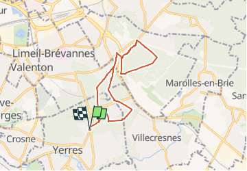

Length
13.2 km

Max alt
119 m

Uphill gradient
101 m
Km-Effort
14.5 km

Min alt
87 m

Downhill gradient
100 m
Boucle
Yes
Creation date :
2022-10-06 17:56:36.121
Updated on :
2022-10-06 17:57:27.248
3h18
Difficulty : Difficult

FREE GPS app for hiking
 SityTrail
IGN / Geographical institutes
SityTrail Plus
The world is yours!
About
Trail Walking of 13.2 km to be discovered at Ile-de-France, Essonne, Yerres. This trail is proposed by jeanmarcMasson.
Positioning
Country:
France
Region :
Ile-de-France
Department/Province :
Essonne
Municipality :
Yerres
Location:
Unknown
Start:(Dec)
Start:(UTM)
463173 ; 5396889 (31U) N.
Comments