


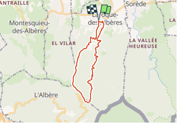
Laroque des Albères puis d'Orella coll de l' ullat le belvédère de la tour

jeanic63
User

Length
14.3 km

Max alt
1018 m

Uphill gradient
946 m
Km-Effort
27 km

Min alt
105 m

Downhill gradient
947 m
Boucle
Yes
Creation date :
2022-10-07 06:19:43.152
Updated on :
2023-10-21 08:09:25.986
8h00
Difficulty : Very difficult

FREE GPS app for hiking
 SityTrail
IGN / Geographical institutes
SityTrail Plus
The world is yours!
About
Trail Walking of 14.3 km to be discovered at Occitania, Pyrénées-Orientales, Laroque-des-Albères. This trail is proposed by jeanic63.
Description
départ parking de la chapelle Sant Sébastia rue de rocavilla laroque des Albères
Positioning
Country:
France
Region :
Occitania
Department/Province :
Pyrénées-Orientales
Municipality :
Laroque-des-Albères
Location:
Unknown
Start:(Dec)
Start:(UTM)
494300 ; 4707735 (31T) N.
Comments