


2022-10-09_08h10m01_roue-des-forts-20-km

randolea
User
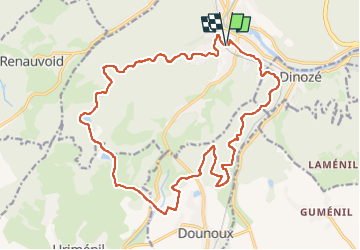

Length
21 km

Max alt
512 m

Uphill gradient
474 m
Km-Effort
27 km

Min alt
348 m

Downhill gradient
473 m
Boucle
Yes
Creation date :
2022-10-09 06:10:02.646
Updated on :
2022-10-09 06:10:03.637

FREE GPS app for hiking
 SityTrail
IGN / Geographical institutes
SityTrail Plus
The world is yours!
About
Trail of 21 km to be discovered at Grand Est, Vosges, Épinal. This trail is proposed by randolea.
Positioning
Country:
France
Region :
Grand Est
Department/Province :
Vosges
Municipality :
Épinal
Location:
Unknown
Start:(Dec)
Start:(UTM)
310451 ; 5335883 (32U) N.
Comments