


Rando verte et Bleu 10,5 km

jeanmarcMasson
User GUIDE
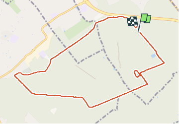

Length
10.5 km

Max alt
93 m

Uphill gradient
67 m
Km-Effort
11.4 km

Min alt
76 m

Downhill gradient
66 m
Boucle
Yes
Creation date :
2022-10-09 08:43:51.97
Updated on :
2022-10-09 11:25:20.702
2h20
Difficulty : Medium

FREE GPS app for hiking
 SityTrail
IGN / Geographical institutes
SityTrail Plus
The world is yours!
About
Trail Walking of 10.5 km to be discovered at Ile-de-France, Essonne, Montgeron. This trail is proposed by jeanmarcMasson.
Positioning
Country:
France
Region :
Ile-de-France
Department/Province :
Essonne
Municipality :
Montgeron
Location:
Unknown
Start:(Dec)
Start:(UTM)
460745 ; 5392805 (31U) N.
Comments