


Idée randonnée

magbjo
User
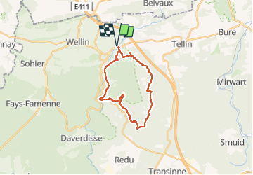

Length
19.7 km

Max alt
420 m

Uphill gradient
548 m
Km-Effort
27 km

Min alt
188 m

Downhill gradient
548 m
Boucle
Yes
Creation date :
2022-10-09 07:08:28.0
Updated on :
2022-10-09 12:11:35.304
5h02
Difficulty : Unknown

FREE GPS app for hiking
 SityTrail
IGN / Geographical institutes
SityTrail Plus
The world is yours!
About
Trail Trail of 19.7 km to be discovered at Wallonia, Luxembourg, Wellin. This trail is proposed by magbjo.
Positioning
Country:
Belgium
Region :
Wallonia
Department/Province :
Luxembourg
Municipality :
Wellin
Location:
Unknown
Start:(Dec)
Start:(UTM)
654031 ; 5549648 (31U) N.
Comments