Magnée Forêt Saint Hadelin 221010

chantalandre
User
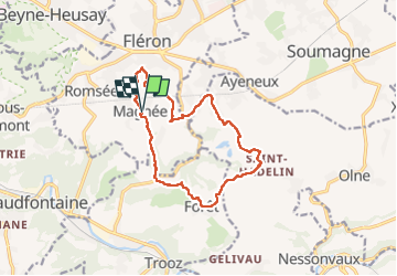

Length
12.3 km

Max alt
265 m

Uphill gradient
324 m
Km-Effort
16.7 km

Min alt
107 m

Downhill gradient
325 m
Boucle
Yes
Creation date :
2022-10-10 07:23:46.0
Updated on :
2022-10-11 18:48:12.087
3h01
Difficulty : Medium

FREE GPS app for hiking
 SityTrail
IGN / Geographical institutes
SityTrail Plus
The world is yours!
About
Trail Walking of 12.3 km to be discovered at Wallonia, Liège, Fléron. This trail is proposed by chantalandre.
Positioning
Country:
Belgium
Region :
Wallonia
Department/Province :
Liège
Municipality :
Fléron
Location:
Unknown
Start:(Dec)
Start:(UTM)
689799 ; 5609084 (31U) N.
Comments