


08/10/22 - Romanswiller

delm
User
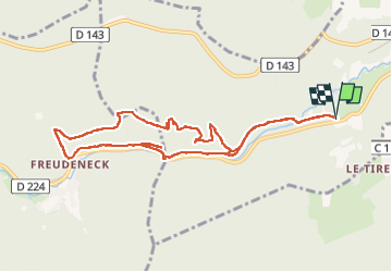

Length
9.8 km

Max alt
482 m

Uphill gradient
289 m
Km-Effort
13.6 km

Min alt
254 m

Downhill gradient
289 m
Boucle
Yes
Creation date :
2022-10-09 12:55:58.0
Updated on :
2022-10-10 15:05:04.454
2h39
Difficulty : Difficult

FREE GPS app for hiking
 SityTrail
IGN / Geographical institutes
SityTrail Plus
The world is yours!
About
Trail Walking of 9.8 km to be discovered at Grand Est, Bas-Rhin, Romanswiller. This trail is proposed by delm.
Positioning
Country:
France
Region :
Grand Est
Department/Province :
Bas-Rhin
Municipality :
Romanswiller
Location:
Unknown
Start:(Dec)
Start:(UTM)
380426 ; 5388131 (32U) N.
Comments